Tuesday, April 26, 2011

Blog Topic #11 -- What's Up with Strange Maps?

Before I begin this blog, I must announce that this is to be my last blog.  Sadly it is April, almost May, and that means the end of the semester.  I have enjoyed my blog quite a bit and hopefully I may post here again someday!

For my final topic, I am suppose to find a strange map, post it here, and write a brief paragraph about it.  However, if you look at the rest of my posts, you may notice I am anything but brief.  For once, I intend to follow directions to the letter so here is my map.

101203_autocomplete


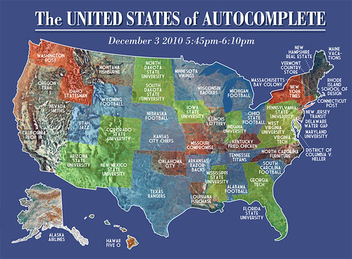
Now this is indeed a strange map.  Although it may look like the United States, every state is labeled incorrectly.  For example, Nebraska is called "Nebraska Football".  This might lead one to think that each state is labeled according to a sport, but if you look at other states such as Alaska, which is called "Alaska Airlines", it is quite clear that sports are not the theme of this map.  So how exactly are the states labeled?

Well, if you have ever been on Google, you may have noticed that when you type in the first few letters or words of your search query, the Internet pops up suggestions for you.  It looks something like this...
The creator of this map typed each state's name into Google and chose the first auto-completion option.  He then mapped it onto a United States map and created the image we see above.

Although at first we may think, "Well that's nice and all, but what purpose does it serve to geography?"  Well, if you look at each name, you can determine what is probably an important part of that state or something that is commonly looked up on the Internet by people regarding that state.  For Nebraska, Cornhusker football is fairly important and in Alaska, many people would probably book airline tickets to fly there because driving is not as plausible as flying.  KFC, also known as Kentucky Fried Chicken, is a major fast food chain in the US.  It only makes sense that when one is searching with the term "Kentucky" that KFC is going to be a top hit.  When you really begin to scrutinize the map, most of it just makes sense.

So what can this teach us about Geography?  When people think of Geography, the thought that commonly comes to mind is maps and directions.  But just like this strange map, there is much more to the subject than simply knowing where Zimbabwe is in the world.  There is cultural geography, physical geography, demography, and so much more.  Just like almost anything can be mapped, almost anything in the world is part of the study of Geography.

So I'll end this blog with an encouragement to get out there and explore your world!  You'll never know just what you'll discover!  To finish off, here are a few pictures of my adventures.

Twin Lakes, Mammoth California

Pere Marquett River, Manistee Michigan

Old Towne, Omaha Nebraska

Saturday, April 23, 2011

Blog Topic #10 -- What's Up with Africa?

For many centuries, Africa was known as the "Dark Continent" because of the lack of European exploration.  Today it is known for its conflict, corruption, poor living conditions, and bad economic structure.  Because of this many Western countries such as the United States have poured in billions of dollars of financial aid to the poor African countries to help them become good, more developed countries in the new globalized world.  However, most of this money never reaches the poor, but is rather used by the few, elite African leaders.  So the question posed to us today is, "Should we continue to give Africa monetary aid or find some other way?"  Before we can answer this, we need to look at all of the facts.

Many plans have been implemented in the past to help Africa, but all have met with failure.  Starting in the 1960's, $500 billion dollars of aid has been given to Africa from wealthier countries with an average of at least $50 billion each year.  Many relief plans have been created such as the ones the UN in held in 1985 and 1996, but once they are over, nothing changes.  The only thing these efforts have accomplished is dependence.  50% of Ghana and Uganda's budgets are apparently aid dependent.  That means without our aid, these countries have no means of fulfilling their yearly needs. So where has all of the $500 billion gone and where is the current $50 billion going?  According to the evidence, straight into the pockets of the wealthy government leaders.

It is not an unknown fact that there is corruption in the governments of Africa.  The wealthy leaders use the money they receive for their own benefit rather than the benefit of their people.  In fact, about 40% of all money in Africa is invested outside the continent and the World Bank estimates about 40% is deposited in foreign banks!  More evidence continues to pour in with cases like that of Nigeria's Inspector General Tafa Balogun who had apparently deposited around $52 million in 15 different bank accounts.  According to the Nigerian Economic and Financial Crimes Commission, military leaders have stolen around $500 billion.  That is equal to the aid given by Western countries to help Africa!  I think it is quite clear just what has happened to Africa's aid money.

So what are we to do?  With the Per Capita Income lower than it was in the 1970's and with 350 million people, about half the population, living on less than a dollar a day, we cannot just turn our back on Africa.  However, giving them money will not help their cause much either and may even make things worse!  It is a sticky situation that we need to resolve, but there seems to be no clear solution.  I think the best solution is to remove all monetary aid from Africa and begin helping them in other ways, such as providing help with development.  The only successful countries are those that are independent, not dependent.  Already some African countries, such as South Africa, have pulled themselves ahead in the world.  If the same kind of help that was given to South Africa is given to the rest of the countries, I believe that eventually they will pull through as well.

If you are interested in reading more, I found an interesting article online concerning this issue of African Aid.  Check out this link!


Until next time!


Monday, April 18, 2011

Blog Topic #9 -- What's Up with The Middle East


For many of us, the term "Middle East" usually brings to mind images of conflict, oil, and general unrest.  This region, composed of North Africa and Southwest Asia, is one of the prime areas for conflict.  The problem is, this conflict can directly affect us because of the major resource in the area....oil.  Gas prices are spiking due to recent protests in areas like Libya and Egypt.  General unrest also makes travel to the region unsafe.  The United States often places warnings on areas in the Middle East telling citizens to avoid travel there.  Most recently in April, the U.S. Government told citizens to avoid travel to Syria and Lebanon because of the political strife there.

So what are all these protests about?  Perhaps the protest making the news most recently are those in Libya.  Protesters in Libya have been trying to remove Moammar Gaddafi, the leader for the past 42 years, from power since January of 2011.  Often these protests ended with the calling in of Gaddafi's security forces and the death or wounding of numerous protesters.  In February one protest resulting in around 200 deaths!  More recently, the protesters have turned into rebels who are revolting against the government for their freedom.  While the government continues to deny military action against these freedom fighters, European nations as well as the U.S. have determined otherwise and as of March 11, most European nations have stopped recognizing Gaddafi as the leader of Libya.  Yet the conflict continues despite numerous casualties.
So what are the Libyan people attempting to accomplish?  It is merely a matter of freedom and human rights.  Gaddafi's reign has resulted in the public executions of anyone who did not agree with him and complete dictatorship.  Libya has been named the most censored area of the region.  Because of this, citizens want to be rid of Gaddafi and to have a democracy with free elections.  Considering that oil makes up most of the country's national income, these protest directly affect oil importing countries, especially European countries which import most of the Libyan oil.

Libya, however, is not the only area of the region that is undergoing massive protests and riots.  Egypt has also been experiencing unrest since the removal of President Hosni Mubarak from power.  Protesters pour out daily demanding the trial of their former leader.  Some have even stormed government buildings in hopes of finding incriminating evidence against the former President's administration.  As the country prepares for new leadership, many Christians have been forced to flee Egypt because of the Muslim mobs.  Some Christians have already been killed during the burning of churches by said mobs.  Because most of the country is Muslim, it is likely that the new government will also be Muslim based causing even more reasons for Christians to flee.

With continued growing unrest in the region, it is no wonder we are paying four dollars at the pump!  Oil is such a major part of this region bringing in most of the income for many countries.  Over half of the world's proven oil reserves are in the Middle East and if those areas are in conflict, the worth of the oil is going to spike.  As citizens of other countries, we need to stay informed of these situations to better understand the world around us as globalization continues to bind us together.

Well it will just have to be a shorter blog this time!  For more information on recent events, check out this website.

Friday, April 15, 2011

Blog Topic #8 -- What's Up with Google Earth?

Throughout my study of geography, I have come to love and appreciate a simple tool not many people probably use on a daily basis if at all.  That tool is a program created by Google called Google Earth.  When in Google Earth, you can fly around the globe, zoom in to cities or countries, create personal tours, and much more.

Google Earth was released in 2005 for use on people's personal computers.  It's images come from satellites that take pictures of the earth as they orbit.  Because of this, all images can be viewed in 3D thus allowing the globe to also be viewed in 3D as well.  This is beneficial because it can allow a person to view the world as it truly is, not altered as it would appear on a 2D map.  It also has numerous "layer" features that put information onto the globe such as borders, roads, clouds, and many other things. 

One such layer is known as 3D buildings.  This layer makes buildings, mountains, and anything with elevation appear 3D as they do in real life.  This can help also provide perspective into how the area looks in real life.  For example, one could turn on 3D buildings and zoom Washington D.C.,  The image they would receive would look like this...
Using this feature allows one to almost literally tour the location without being there!

As mentioned earlier, Google Earth can also give a better interpretation of what the world is really like.  It can increase perspective and make us think about the world in ways different than we do now.  For example, I always thought that the top of the globe contained a small land mass similar to Antarctica where the North Pole was located.  However, upon looking at this, my perspective was changed.


Apparently the top of the globe consists mainly of Greenland, a few islands, and water. There is no "North Antarctica" like I always imagined; how I saw the earth has changed and that is only in one region.  For example, I can also see that the quickest way from Canada to Sweden would be across the top of the globe, not around the world as we would imagine.  This image also shows just how close Alaska is to Russia, China, and Japan compared to the rest of the United States.  Places that seemed very far away have become closer or farther away by looking at one image.  What would happen if we looked at two?
Now we are looking at the bottom of the globe, at Antarctica.  This shows just how far away we are from Antarctica, but yet how close the tip of South America is to it.  I always imagined that Antarctica was this distant, very isolated piece of land from the rest of the world.  Now I see that it is closer to South America than New Zealand is to Australia!  In fact, it is only about 825 miles away (and yes, I used Google Earth to figure that out)!

So in conclusion, I greatly encourage anyone who has never seen or heard of Google Earth to try it out!  Before long, you'll become a huge fan of it as I have and might even stoop to spending your afternoon touring the globe virtually. (and yes, I have done this several times).  Besides being a great tool, it can help expand your view of our planet Earth.

Have Fun!

Sunday, April 3, 2011

Blog Topic #7 -- What's Up with Afghanistan?


Our next stop is a less than peaceful area of the world.  Today we head to the dry, semi-arid, mountainous country known as Afghanistan.  The name is very familiar in the world because of the U.S.'s ongoing War on Terror that is primarily centered in that region.  But before we jump into that, let us take a quick look at the background of Afghanistan.


Afghanistan is a multinational state meaning that its state contains more than one nation.  It covers a landmass of about 250,000 square miles or about the size of the state of Texas.  The land is covered with mountains making it one of the most mountainos countries in the world.  Its name literally means "land of the Afghans"; Afghans are another name for the Pashtun tribe.  Although the country is very diverse in language and tribes, the Pashtun tribe is the largest ethic group in the country.  In fact, the country itself was founded in 1747 by the uniting of the Pashtun tribes.  Unlike other areas in the region, Afghanistan was never colonized by an outside force, such as European countries.

Over the years, Afghanistan has been a hot spot for fighting.  During the colonization of the region by the British Empire, the Afghans resisted and fought the British forcing them to eventually give up.  The Durand Line Agreement, an agreement between British India and Afghanistan, formed the border between British possessions and Afghanistan.  To this day, the 1,600 mile long line serves as the border between Afghanistan and Pakistan. 


In 1979, the USSR attempted to overtake Afghanistan.  Like the British, they were met with resistance in the form of Mujahideen freedom fighters.  However, many Pashtuns fled the country into nearby areas such as Iran and Pakistan.  It was during this time that the famous "Afghan Girl" picture was taken for National Geographic's cover.  With the support of the U.S. government, the Mujahideen pushed the Soviets out of their country in 1989.  However, this led to the rise of another term most people are familiar with, the Taliban.  After the 9/11 attacks on the U.S., troops moved into Afghanistan and removed the Taliban from power in 2001.  Ever since, U.S. troops have been fighting insurgents, terrorists, the Taliban, and other groups in the mountains of Afghanistan.

Recently in class we watched the movie "Restrepo", a documentary like movie that follows one platoon of U.S. soldiers in Afghanistan's Korengal Valley for a year.  With real footage and interviews with the soldiers, it makes the war in Afghanistan come to life, and the picture is not pretty.  Because of the mountains, rough terrain, changing climate, and many other factors, fighting in Afghanistan is not easy.  The British and Soviets were defeated for a reason.  The Korengal especially is a difficult place and considered to have been the most dangerous postings for a U.S. soldier. 

U.S. troops first began fighting insurgents in Korengal in 2005.  Through the hard work and bravery of groups, like the platoon in Restrepo, the U.S. managed to gain a foothold three miles into the valley.  Because of lack of roads, transportation was a problem.  The residents of the valley were also not always pleased by the troops stationed there.  During weekly shuras, or meetings, with local village elders, troops would try to talk about important issues with the elders.  However, often these talks did not accomplish anything.  With the insurgents having free reign of most of the territory and because of lack of cooperation, in 2010 the U.S. government decided to pull out of the Korengal.  All the work and progress that had been made was lost, but it was considered by the government to be an acceptable loss. (I personally feel it is not, especially after watching the movie).

Although we all are familiar with the War on Terror, there is another war going on in Afghanistan, the War on Opium.  Very little land is usable for crops and unfortunately the crop of choice is opium.  In fact, Afghanistan is the world's leading country in opium production.  Under the Taliban, Afghans had no restrictions on what they could do so many made good money by smuggling opium over the borders into Pakistan and Iran.  Since opium is an illegal drug, U.S. Marines have made it their mission to rid Afghanistan of opium production.  This is accomplished through methods such as seed and product confiscation.  In addition, U.S. and British aid agencies have supplied money to fund make-work projects in hopes of turning opium farmers attention to other lines of work.  Although there has been a decrease in production, locals are none too pleased with the interference and continue to try to grow opium rather than wheat or another crop.  Because of this, the war continues on same as the other war.


Visit...
...to learn more about the Afghan Girl and how National Geographic found her.

For more information about the Korengal and the U.S.'s withdrawal, go to...


That's all from Afghanistan!  If you get a chance, I highly recommend that you watch "Restrepo" as it gives you a good look at just what our troops are doing.